《山东大学学报(理学版)》 ›› 2024, Vol. 59 ›› Issue (11): 110-125.doi: 10.6040/j.issn.1671-9352.0.2022.553
孙金欣1( ),韩美1,*(),孔凡彪1,魏帆2
Jinxin SUN1(),Mei HAN1,*(),Fanbiao KONG1,Fan WEI2
摘要:
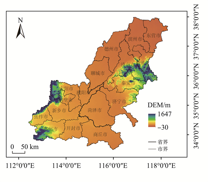
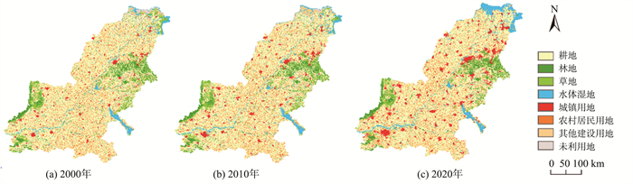
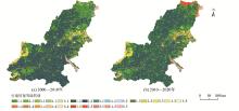
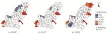
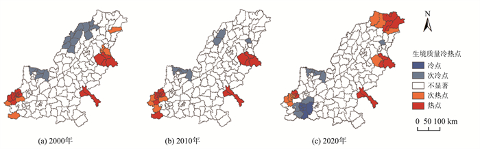
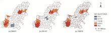
在城市化进程中, 自然生境因受到人为扰动而产生不同程度的退化, 阻碍了区域高质量发展, 生境质量与城市化发展的耦合协调关系亟待调和。本文以黄河下游为研究区, 采用生态系统服务与权衡的综合评估(integrated valuation of ecosystem service and trade-offs, InVEST)模型分析2000—2020年黄河下游生境质量的时空演变特征, 并结合表征城市化水平的灯光指数, 借助耦合协调模型和解耦模型评估生境质量与城市化水平的交互耦合关系。结果表明: (1) 2000—2020年, 黄河下游生境质量整体水平较差但逐渐趋于改善, 生境质量较高的地区主要集中在沿海、沿湖湿地, 西南和东部的山地丘陵, 总体呈现出中部低、边缘高的态势, 分布格局较稳定。(2)黄河下游城市化水平总体提高, 区域差异增强, 逐渐发展成为以济-淄、郑-新城市圈为重要增长极城市化水平分布格局。(3)黄河下游生境质量与城市化的耦合协调阶段属于基本协调阶段, 向失调方向转化的县(区)减少, 解耦类型主要为强负解耦和弱解耦两种消极解耦类型, 且消极解耦类型占比逐渐减少, 两系统的耦合协调程度加深, 解耦程度降低, 整体向协调化方向发展。
中图分类号:
| 1 |
王晓楠, 孙威. 黄河流域资源型城市转型效率及其影响因素[J]. 地理科学进展, 2020, 39 (10): 1643- 1655.
doi: 10.18306/dlkxjz.2020.10.004 |
|
WANG Xiaonan , SUN Wei . Transformation efficiency of resource-based cities in the Yellow River Basin and its influencing factors[J]. Progress in Geography, 2020, 39 (10): 1643- 1655.
doi: 10.18306/dlkxjz.2020.10.004 |
|
| 2 |
岳立, 薛丹. 黄河流域沿线城市绿色发展效率时空演变及其影响因素[J]. 资源科学, 2020, 42 (12): 2274- 2284.
doi: 10.18402/resci.2020.12.02 |
|
YUE Li , XUE Dan . Spatiotemporal change of urban green development efficiency in the Yellow River Basin and influencing factors[J]. Resources Science, 2020, 42 (12): 2274- 2284.
doi: 10.18402/resci.2020.12.02 |
|
| 3 | 黄鑫, 程文仕, 李晓丹, 等. 甘肃省生境质量变化的图谱特征[J]. 应用生态学报, 2020, 31 (9): 3131- 3140. |
| HUANG Xin , CHENG Wenshi , LI Xiaodan , et al. Spectrum characteristics of habitat quality changes in Gansu Province, China[J]. Chinese Journal of Applied Ecology, 2020, 31 (9): 3131- 3140. | |
| 4 | 周婷, 陈万旭, 李江风, 等. 神农架林区人类活动与生境质量的空间关系[J]. 生态学报, 2021, 41 (15): 6134- 6145. |
| ZHOU Ting , CHEN Wanxu , LI Jiangfeng , et al. Spatial relationship between human activities and habitat quality in Shennongjia Forest Region from 1995 to 2015[J]. Acta Ecologica Sinica, 2021, 41 (15): 6134- 6145. | |
| 5 | CHEN T Y , HWANG G W , MAYFIELD A B , et al. The development of habitat suitability models for fiddler crabs residing in subtropical tidal flats[J]. Ocean & Coastal Management, 2019, 182, 104931. |
| 6 |
ZHANG Z C , ZHANG H J , FENG J , et al. Evaluation of social values for ecosystem services in urban riverfront space based on the SolVES model: a case study of the Fenghe River, Xi'an, China[J]. International Journal of Environmental Research and Public Health, 2021, 18 (5): 2765.
doi: 10.3390/ijerph18052765 |
| 7 | BENSON C , SHERROUSE D J , ANCONA Z H . Social values for ecosystem services (SolVES): open-source spatial modeling of cultural services[J]. Environmental Modelling & Software, 2022, 148, 105259. |
| 8 |
WU J Y , LUO J G , ZHANG H , et al. Projections of land use change and habitat quality assessment by coupling climate change and development patterns[J]. The Science of the Total Environment, 2022, 847, 157491.
doi: 10.1016/j.scitotenv.2022.157491 |
| 9 |
SUN X Y , JIANG Z , LIU F , et al. Monitoring spatio-temporal dynamics of habitat quality in Nansihu Lake Basin, eastern China, from 1980 to 2015[J]. Ecological Indicators, 2019, 102, 716- 723.
doi: 10.1016/j.ecolind.2019.03.041 |
| 10 | 张学儒, 周杰, 李梦梅. 基于土地利用格局重建的区域生境质量时空变化分析[J]. 地理学报, 2020, 75 (1): 160- 178. |
| ZHANG Xueru , ZHOU Jie , LI Mengmei . Analysis on spatial and temporal changes of regional habitat quality based on the spatial pattern reconstruction of land use[J]. Acta Geographica Sinica, 2020, 75 (1): 160- 178. | |
| 11 | 冯舒, 孙然好, 陈利顶. 基于土地利用格局变化的北京市生境质量时空演变研究[J]. 生态学报, 2018, 38 (12): 4167- 4179. |
| FENG Shu , SUN Ranhao , CHEN Liding . Spatio-temporal variability of habitat quality based on land use pattern change in Beijing[J]. Acta Ecologica Sinica, 2018, 38 (12): 4167- 4179. | |
| 12 | 褚琳, 张欣然, 王天巍, 等. 基于CA-Markov和InVEST模型的城市景观格局与生境质量时空演变及预测[J]. 应用生态学报, 2018, 29 (12): 4106- 4118. |
| CHU Lin , ZHANG Xinran , WANG Tianwei , et al. Spatial-temporal evolution and prediction of urban landscape pattern and habitat quality based on CA-Markov and InVEST model[J]. Chinese Journal of Applied Ecology, 2018, 29 (12): 4106- 4118. | |
| 13 | 黄木易, 岳文泽, 冯少茹, 等. 基于InVEST模型的皖西大别山区生境质量时空演化及景观格局分析[J]. 生态学报, 2020, 40 (9): 2895- 2906. |
| HUANG Muyi , YUE Wenze , FENG Shaoru , et al. Spatial-temporal evolution of habitat quality and analysis of landscape patterns in Dabie Mountain area of west Anhui Province based on InVEST model[J]. Acta Ecologica Sinica, 2020, 40 (9): 2895- 2906. | |
| 14 | 周亮, 唐建军, 刘兴科, 等. 黄土高原人口密集区城镇扩张对生境质量的影响: 以兰州、西安-咸阳及太原为例[J]. 应用生态学报, 2021, 32 (1): 261- 270. |
| ZHOU Liang , TANG Jianjun , LIU Xingke , et al. Effects of urban expansion on habitat quality in densely populated areas on the Loess Plateau: a case study of Lanzhou, Xi'an-Xianyang and Taiyuan, China[J]. Chinese Journal of Applied Ecology, 2021, 32 (1): 261- 270. | |
| 15 | 庞惠心, 安睿, 刘艳芳. 武汉市城市化进程中生境质量对景观格局的样带响应[J]. 生态科学, 2022, 41 (3): 33- 43. |
| PANG Huixin , AN Rui , LIU Yanfang . Gradient response of habitat quality to landscape pattern based on transect method in urbanization procession in Wuhan[J]. Ecological Science, 2022, 41 (3): 33- 43. | |
| 16 | 尚俊, 蔡海生, 龙月, 等. 基于InVEST模型的鄱阳湖区生境质量时空演化及其变迁特征分析[J]. 长江流域资源与环境, 2021, 30 (8): 1901- 1915. |
| SHANG Jun , CAI Haisheng , LONG Yue , et al. Temporal-spatial distribution and transition of habitat quality in Poyang Lake region based on INVEST model[J]. Resources and Environment in the Yangtze Basin, 2021, 30 (8): 1901- 1915. | |
| 17 | 曾志伟, 杨华, 宁启蒙, 等. 洞庭湖区土地利用强度演变及其对生态系统服务的影响[J]. 经济地理, 2022, 42 (9): 176- 185. |
| ZENG Zhiwei , YANG Hua , NING Qimeng , et al. Temporal and spatial evolution of land use intensity and its impact on ecosystem services in Dongting Lake zone[J]. Economic Geography, 2022, 42 (9): 176- 185. | |
| 18 | LI X , LIU Z S , LI S J , et al. Multi-scenario simulation analysis of land use impacts on habitat quality in Tianjin based on the PLUS model coupled with the InVEST model[J]. Sustainability, 2022, 14 (11): 6923. |
| 19 | 常玉旸, 高阳, 谢臻, 等. 京津冀地区生境质量与景观格局演变及关联性[J]. 中国环境科学, 2021, 41 (2): 848- 859. |
| CHANG Yuyang , GAO Yang , XIE Zhen , et al. Spatiotemporal evolution and spatial correlation of habitat quality and landscape pattern over Beijing-Tianjin-Hebei region[J]. China Environmental Science, 2021, 41 (2): 848- 859. | |
| 20 | 聂宇, 杨彦敏, 王一航, 等. 拉萨市城关区近50年城市扩展过程对自然生境质量的综合影响[J]. 生态学报, 2022, 42 (6): 2202- 2220. |
| NIE Yu , YANG Yanmin , WANG Yihang , et al. Comprehensive impacts of urban expansion on natural habitat quality in Chengguan District of Lhasa City in recent 50 years[J]. Acta Ecologica Sinica, 2022, 42 (6): 2202- 2220. | |
| 21 | 李岩林, 程钢, 杨杰, 等. 夜光遥感数据支持下的区域经济空间格局精细化模拟: 以河南省为例[J]. 地域研究与开发, 2020, 39 (4): 41- 47. |
| LI Yanlin , CHENG Gang , YANG Jie , et al. Refined spatial simulation of regional economy based on nighttime lighting data from remote sensing: a case study of Henan Province[J]. Areal Research and Development, 2020, 39 (4): 41- 47. | |
| 22 | 杨智威, 陈颖彪, 吴志峰, 等. 粤港澳大湾区城市热岛空间格局及影响因子多元建模[J]. 资源科学, 2019, 41 (6): 1154- 1166. |
| YANG Zhiwei , CHEN Yingbiao , WU Zhifeng , et al. Spatial pattern of urban heat island and multivariate modeling of impact factors in the Guangdong-Hong Kong-Macao Greater Bay area[J]. Resources Science, 2019, 41 (6): 1154- 1166. | |
| 23 | 潘竟虎, 胡艳兴. 基于夜间灯光数据的中国多维贫困空间识别[J]. 经济地理, 2016, 36 (11): 124- 131. |
| PAN Jinghu , HU Yanxing . Spatial identification of multidimensional poverty in China based on nighttime light remote sensing data[J]. Economic Geography, 2016, 36 (11): 124- 131. | |
| 24 | 陈颖彪, 郑子豪, 吴志峰, 等. 夜间灯光遥感数据应用综述和展望[J]. 地理科学进展, 2019, 38 (2): 205- 223. |
| CHEN Yingbiao , ZHENG Zihao , WU Zhifeng , et al. Review and prospect of application of nighttime light remote sensing data[J]. Progress in Geography, 2019, 38 (2): 205- 223. | |
| 25 | 陈晋, 卓莉, 史培军, 等. 基于DMSP/OLS数据的中国城市化过程研究: 反映区域城市化水平的灯光指数的构建[J]. 遥感学报, 2003, 7 (3): 168-175, 241. |
| CHEN Jin , ZHUO Li , SHI Peijun , et al. The study on urbanization process in China based on DMSP/OLS data: development of a light index for urbanization level estimation[J]. Journal of Remote Sensing, 2003, 7 (3): 168-175, 241. | |
| 26 | GRAFIUS D R , CORSTANJE R , WARREN P H , et al. The impact of land use/land cover scale on modelling urban ecosystem services[J]. Landscape Ecology, 2016, 31 (7): 1509- 1522. |
| 27 | 韩艳莉, 陈克龙, 于德永. 土地利用变化对青海湖流域生境质量的影响[J]. 生态环境学报, 2019, 28 (10): 2035- 2044. |
| HAN Yanli , CHEN Kelong , YU Deyong . Evaluation on the impact of land use change on habitat quality in Qinghai Lake basin[J]. Ecology and Environmental Sciences, 2019, 28 (10): 2035- 2044. | |
| 28 | 谢余初, 巩杰, 张素欣, 等. 基于遥感和InVEST模型的白龙江流域景观生物多样性时空格局研究[J]. 地理科学, 2018, 38 (6): 979- 986. |
| XIE Yuchu , GONG Jie , ZHANG Suxin , et al. Spatiotemporal change of landscape biodiversity based on InVEST model and remote sensing technology in the Bailong River Watershed[J]. Scientia Geographica Sinica, 2018, 38 (6): 979- 986. | |
| 29 | 彭建, 吴见, 徐飞雄, 等. 基于价值评估的黄山市生境质量时空演变特征分析[J]. 生态学报, 2021, 41 (2): 665- 679. |
| PENG Jian , WU Jian , XU Feixiong , et al. Spatio-temporal evolution characteristics of habitat quality in typical tourism cities based on value evaluation: a case study of Huangshan[J]. Acta Ecologica Sinica, 2021, 41 (2): 665- 679. | |
| 30 | 张可云, 张颖. 不同空间尺度下黄河流域区域经济差异的演变[J]. 经济地理, 2020, 40 (7): 1- 11. |
| ZHANG Keyun , ZHANG Ying . The evolution of regional economic disparity in the Yellow River Basin at different spatial scales[J]. Economic Geography, 2020, 40 (7): 1- 11. | |
| 31 | 刘建华, 黄亮朝, 左其亭. 黄河下游经济-人口-资源-环境和谐发展水平评估[J]. 资源科学, 2021, 43 (2): 412- 422. |
| LIU Jianhua , HUANG Liangchao , ZUO Qiting . Evaluation of harmonious development of economy-population-resource-environment in the lower reaches of the Yellow River[J]. Resources Science, 2021, 43 (2): 412- 422. | |
| 32 | 牛惠, 吴潇, 程慧娴, 等. 黄河下游沿黄地市农业高质量发展水平评价及比较研究[J]. 中国农业资源与区划, 2022, 43 (10): 19- 29. |
| NIU Hi , WU Xiao , CHENG Huixian , et al. Evaluation and comparative study on high quality agricultural development level of cities along the Lower Yellow River[J]. Chinese Journal of Agricultural Resources and Regional Planning, 2022, 43 (10): 19- 29. | |
| 33 | 周园, 曹威威, 杨迅周, 等. 基于改进引力模型的黄河下游沿岸城市空间联系特征分析[J]. 地域研究与开发, 2021, 40 (6): 63- 68. |
| ZHOU Yuan , CAO Weiwei , YANG Xunzhou , et al. Urban spatial linkage characteristics along the lower Yellow River based on improved gravity model[J]. Areal Research and Development, 2021, 40 (6): 63- 68. | |
| 34 | 张立贤, 任浙豪, 陈斌, 等. 中国长时间序列逐年人造夜间灯光数据集(1984—2020)[R]. [出版地不详]: 国家青藏高原科学数据中心, 2021. |
| ZHANG Lixian, REN Zhehao, CHEN Bin, et al. A prolonged artificial nighttime-light dataset of China(1984-2020)[R]. [S. l. ]: National Tibetan Plateau Data Center, 2021. | |
| 35 | 赵筱青, 石小倩, 李驭豪, 等. 滇东南喀斯特山区生态系统服务时空格局及功能分区[J]. 地理学报, 2022, 77 (3): 736- 756. |
| ZHAO Xiaoqing , SHI Xiaoqian , LI Yuhao , et al. Spatio-temporal pattern and functional zoning of ecosystem services in the Karst mountainous areas of southeastern Yunnan[J]. Acta Geographica Sinica, 2022, 77 (3): 736- 756. | |
| 36 | 刘长雨, 杨洁, 谢保鹏, 等.黄河流域甘青段生境质量时空特征及其地形梯度效应[EB/OL].(2023-08-13)[2022-09-13].https://doi.org/10.13254/j.jare.2022.0216 . |
| LIU Changyu, YANG Jie, XIE Baopeng, et al. Temporal and spatial characteristics of habitat quality and its topographic gradient effect in the Gansu-Qinghai section of the Yellow River basin[EB/OL]. (2022-08-13)[2022-09-13]. https://doi.org/10.13254/j.jare.2022.0216. | |
| 37 | 孙汇颖, 宫巧巧, 刘庆果, 等. 基于土地利用变化的山东省生境质量时空演变特征[J]. 土壤通报, 2022, 53 (5): 1019- 1028. |
| SUN Huiying , GONG Qiaoqiao , LIU Qingguo , et al. Spatio-temporal evolution of habitat quality based on the land-use changes in Shandong Province[J]. Chinese Journal of Soil Science, 2022, 53 (5): 1019- 1028. | |
| 38 | 李子, 张艳芳. 基于InVEST模型的渭河流域干支流生态系统服务时空演变特征分析[J]. 水土保持学报, 2021, 35 (4): 178- 185. |
| LI Zi , ZHANG Yanfang . Spatiotemporal evolution of ecosystem services in the main and tributaries of Weihe River basin based on InVEST model[J]. Journal of Soil and Water Conservation, 2021, 35 (4): 178- 185. | |
| 39 | 彭建, 徐飞雄, 吴见, 等. 典型旅游城市生境质量空间分异及其影响机理研究: 以黄山市为例[J]. 长江流域资源与环境, 2019, 28 (10): 2397- 2409. |
| PENG Jian , XU Feixiong , WU Jian , et al. Spatial differentiation of habitat quality in typical tourist city and their influencing factors mechanisms: a case study of Huangshan city[J]. Resources and Environment in the Yangtze Basin, 2019, 28 (10): 2397- 2409. | |
| 40 | 孙久文, 崔雅琪, 张皓. 黄河流域城市群生态保护与经济发展耦合的时空格局与机制分析[J]. 自然资源学报, 2022, 37 (7): 1673- 1690. |
| SUN Jiuwen , CUI Yaqi , ZHANG Hao . Spatio-temporal pattern and mechanism analysis of coupling between ecological protection and economic development of urban agglomerations in the Yellow River Basin[J]. Journal of Natural Resources, 2022, 37 (7): 1673- 1690. | |
| 41 | 徐辉, 王亿文, 张宗艳, 等. 黄河流域水-能源-粮食耦合机理及协调发展时空演变[J]. 资源科学, 2021, 43 (12): 2526- 2537. |
| XU Hui , WANG Yiwen , ZHANG Zongyan , et al. Coupling mechanism of water-energy-food and spatiotemporal evolution of coordinated development in the Yellow River Basin[J]. Resources Science, 2021, 43 (12): 2526- 2537. | |
| 42 | 杜祥琬, 杨波, 刘晓龙, 等. 中国经济发展与能源消费及碳排放解耦分析[J]. 中国人口·资源与环境, 2015, 25 (12): 1- 7. |
| DU Xiangwan , YANG Bo , LIU Xiaolong , et al. Decoupling analysis of China's economic development, energy consumption and carbon dioxide emission[J]. China Population Resources and Environment, 2015, 25 (12): 1- 7. | |
| 43 | TAPIO P . Towards a theory of decoupling: degrees of decoupling in the EU and the case of road traffic in Finland between 1970 and 2001[J]. Transport Policy, 2005, 12 (2): 137- 151. |
| 44 | 郭莎莎, 陈明星, 刘慧. 城镇化与资源环境的耦合过程与解耦分析: 以北京为例[J]. 地理研究, 2018, 37 (8): 1599- 1608. |
| GUO Shasha , CHEN Mingxing , LIU Hui . Coupling procedure and decoupling analysis of urbanization and resource environment: the study of Beijing[J]. Geographical Research, 2018, 37 (8): 1599- 1608. | |
| 45 | 宋永永, 薛东前, 马蓓蓓, 等. 黄土高原城镇化过程及其生态环境响应格局[J]. 经济地理, 2020, 40 (6): 174- 184. |
| SONG Yongyong , XUE Dongqian , MA Beibei , et al. Urbanization process and its ecological environment response pattern on the Loess Plateau, China[J]. Economic Geography, 2020, 40 (6): 174- 184. | |
| 46 | 蔡开奎, 李金城, 胡梦辰, 等. 流域水文模型的参数全局敏感性分析[J]. 北京大学学报(自然科学版), 2022, 58 (4): 753- 762. |
| CAI Kaikui , LI Jincheng , HU Mengchen , et al. Global sensitivity analysis of hydrological parameters of the watershed simualtion model[J]. Acta Scientiarum Naturalium Universitatis Pekinensis, 2022, 58 (4): 753- 762. | |
| 47 | 徐涵秋. 区域生态环境变化的遥感评价指数[J]. 中国环境科学, 2013, 33 (5): 889- 897. |
| XU Hanqiu . A remote sensing index for assessment of regional ecological changes[J]. China Environmental Science, 2013, 33 (5): 889- 897. | |
| 48 | 刘彦随, 杨忍, 林元城. 中国县域城镇化格局演化与优化路径[J]. 地理学报, 2022, 77 (12): 2937- 2953. |
| LIU Yansui , YANG Ren , LIN Yuancheng . Pattern evolution and optimal paths of county urbanization in China[J]. Acta Geographica Sinica, 2022, 77 (12): 2937- 2953. |
| [1] | 陈浩,王仁卿,刘建. 黄河三角洲城市土地利用与生态环境耦合关系[J]. 《山东大学学报(理学版)》, 2019, 54(7): 11-20. |
| [2] | 任丽军,袁存超,崔兆杰 . 山东省城市化对水资源需求预测研究[J]. J4, 2008, 43(9): 27-30 . |
|